
Roman Features
What is it?
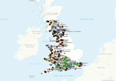
This is a collection of layers produced by Martin Laker from the GIS Team at Bath & North East Somerset. This was a personal project undertaken in his own time to map significant Roman features across Britain. The data is significant for use within B&NES as Bath has such a rich Roman history.
Martin has kindly allows this dataset to be shared with all Parish Online subscribers.
Layers include (in Martin's own words):
- Communications. This layer covers lighthouses, signal stations, watch towers and posting stations. Exactly how signal stations worked, isn’t clear. A posting station (mansio) was a place where horses could be exchanged for people on government business and food and accommodation was available. Generally they were spaced at suitable travelling distances, but some appear to have been sited where a change of horse might be particularly needed – for example at the top of Birdlip Hill, just outside of Gloucester.
- Military sites. These have been styled in three categories:
- Forts. Permanent buildings, including small fortlets. Larger forts include barracks, admin buildings, stores and baths (the latter often outside the walls).
- Practice works. Incomplete earthworks constructed by soldiers during training.
- Camps. Temporary sites where tents were pitched, usually consisting of just an enclosure. Generally these are “marching camps”, but they also include siege camps.
- Temples. Temples are often on hill tops or by river crossings. Although we don’t know the dedication of the majority, many of these appear to be Romano-Celtic deities. Mithras was evidently popular amongst the troops on Hadrian’s Wall, and three forts have shrines.
- Villas. Includes known villas, probably villas (e.g. where a bath house is known), and the much larger Palace at Fishbourne.
- Other buildings. Where possible “Roman Building” on OS has been classified as one of the other layers, leaving this category for commercial, administrative and agricultural buildings, plus those for which there is insufficient evidence to deduce a use.
- Roads. Roads are shown as solid lines where their course is certain and as broken lines where it is uncertain. The many gaps in the network show that there are plenty yet to be discovered. Distances are measured in Roman miles (1 Roman mile = 1.48km).
- Water features. This covers aqueducts, canals and industrial scale open drains. They are all impressive pieces of engineering, with very shallow gradients on the aqueducts. Aqueducts supplied towns, industry and military sites, Dorchester, Dolaucothi gold mines, and Aesica on Hadrian’s Wall being notable examples of each. The canal system of the east of England is an equally fine example of Roman surveying, connecting the Trent to the Witham and then on to the rivers of the Fens. The course of the aqueduct at Cilurnum is inferred from the contours – we only know the inlet point at the fort, although we know who built it and when.
Where does it come from?
Martin Laker, Bath & North East Somerset Council
How often is it updated?
Whenever Martin has time. If you're interested in contributing then contact us through our support channels and we'll put you in touch.
What area does it cover?
Largely completed southwest of a line Chichester – Silchester- Worcester – Wroxeter; also largely complete in Cumbria and north of Hadrian’s Wall.
Partially complete in Kent, East Sussex, Cheshire, Lancashire, Peak District and immediately south of Hadrian’s Wall.
Not started at all: Hadrian’s Wall itself (requires new layer), East side of England and Midlands. Layer for names of rivers, islands, etc.
Wales: Largely completed throughout
Scotland: Largely completed south of Antonine Wall.
Not started: Antonine Wall (needs new layer) and north of it.
How might you use it?
These datasets may be useful for:
- exploring the history of your parish
- taking historical features into account when managing parish business
Data Licence
Copyright Martin Laker.
Technical Blurb
Martin has provided detailed information about these layers. So here they are in his own words:
The Roman Britain collection in Xmap maps Roman sites in Britain. It is an accumulation of sites across the entire Roman period (43 – 410AD) and not all sites or features would have been in existence simultaneously.
Names
Identifying the Roman names of places is a fraught subject. While some, such as Londinium and Aquae Sulis, are definite, many are only know from written sources and which have become corrupted and don’t locate them with certainty. The problems of the Antonine Iternary, Ravenna Cosmography and other sources are discussed in the introductory text to the OS map of Roman Britain, and elsewhere such as here: http://www.romaneranames.uk/
From time to time, new inscriptions are discovered that clarify the name of a place. OS isn’t good at catching up with these, even on MasterMap, as can be seen on the forts along Hadrian’s Wall where they are offset by one from what we now know to be the true location. Similarly, an inscription found at Cerriden, gave it the name Velunia, showed that the list of forts along the Antonine Wall in Ravenna Cosmography run east to west, and not the other way as previously thought.
Names are often abbreviated on inscriptions so without some idea what the name is we are left guessing at its full version – for example, many lead ingots from the Mendips have the location stamp VEB. This is probably Charterhouse, but what the full name is we are left guessing, so Vebriacum is only one possible answer. In any case it might alternatively be a name for the whole Mendip hills. A comprehensive list of known inscriptions and other written sources found in Britain is here: https://romaninscriptionsofbritain.org/
The names I have used are therefore from a composite of sources, and don’t necessarily agree with OS or with www.romaneranames.uk/.
Unmapped features
The following features are not mapped:
- Cemeteries
- Theatres and amphitheatres
- Milestones
Back to Category
MORE INFORMATION