
Environment Agency Flood Datasets
What is it?
This is a collection of datasets from Environment Agency relating to flooding.
Datasets
Risk of flooding from rivers and seas
The dataset shows the chance of flooding from rivers and/or the sea, based on cells of 50m. Each cell is allocated one of four flood risk categories, taking into account flood defences and their condition.
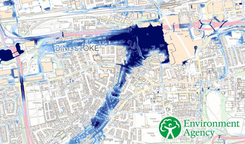
Risk of flooding from surface water - 3.3% annual chance
Shows the extent of flooding from surface water that could result from a flood with a 3.3% chance of happening in any given year.
This dataset is not suitable for identifying whether an individual property will flood.
Risk of flooding from surface water - 1.0% annual chance
Shows the extent of flooding from surface water that could result from a flood with a 1% chance of happening in any given year.
This dataset is not suitable for identifying whether an individual property will flood.
Risk of flooding from surface water - 0.1% annual chance
Shows the extent of flooding from surface water that could result from a flood with a 1% chance of happening in any given year.
This dataset is not suitable for identifying whether an individual property will flood.
Flood Map - Rivers and Seas - Zone 3
This is the best estimate of the areas of land at risk of flooding, when the presence of flood defences are ignored and covers land with a 1 in 100 (1%) or greater chance of flooding each year from Rivers; or with a 1 in 200 (0.5%) or greater chance of flooding each year from the Sea.
This dataset is designed to support flood risk assessments in line with Planning Practice Guidance; and raise awareness of the likelihood of flooding to encourage people living and working in areas prone to flooding to find out more and take appropriate action.
The information provided is largely based on modelled data and is therefore indicative rather than specific.
Flood Map - Rivers and Seas - Zone 2
This is the best estimate of the areas of land at risk of flooding, when the presence of flood defences are ignored and covers land between Zone 3 and the extent of the flooding from rivers or the sea with a 1 in 1000 (0.1%) chance of flooding each year. This dataset also includes those areas defined in Flood Zone 3.
This dataset is designed to support flood risk assessments in line with Planning Practice Guidance; and raise awareness of the likelihood of flooding to encourage people living and working in areas prone to flooding to find out more and take appropriate action.
The information provided is largely based on modelled data and is therefore indicative rather than specific.
Reservoir Flood Extents - Dry Day
This data shows the individual flood extents for all large raised reservoirs in the event that they were to fail and release the water held on a “dry day” when local rivers are at normal levels.
It represents a prediction of a credible worst case scenario, however it’s unlikely that any actual flood would be this large. The data gives no indication of the likelihood or probability of reservoir flooding.
Flood extents are not included for smaller reservoirs or for reservoirs commissioned after the reservoir modelling programme began in October 2016.
Reservoir Flood Extents - Wet Day
This data shows the individual flood extents for all large raised reservoirs in the event that they were to fail and release the water held on a “wet day” when local rivers had already overflowed their banks.
It represents a prediction of a credible worst case scenario, however it’s unlikely that any actual flood would be this large. The data gives no indication of likelihood or probability of reservoir flooding.
Flood extents are not included for smaller reservoirs or for reservoirs commissioned after the reservoir modelling programme began in October 2016.
Reservoir Flood Extents - Fluvial Contribution
This data shows the extent of river flooding added to the reservoir model to determine the impacts of failure on a wet-day. It is not exactly the same as the flooding from rivers shown in the Flood Map for Planning from Rivers and Sea. The fluvial-only extent should only be used to see the impact the reservoir flooding has.
Flood extents are not included for smaller reservoirs or for reservoirs commissioned after the reservoir modelling programme began in October 2016.
Flood Risk Areas
Flood Risk Areas identify locations where there is believed to be significant flood risk. The EU Floods Directive refers to Flood Risk Areas as 'Areas of Potentially Significant Flood Risk' (APSFR).
Flood Risk Areas have been defined by the Environment Agency (main rivers and the sea) and Lead Local Flood Authorities (surface water). Other sources of flooding are not covered. This dataset includes Flood Risk Areas defined for both Cycle 1 (December 2011) and Cycle 2 (December 2018).
Flood Risk Areas are designed to meet the needs of the European Floods Directive. They are designed for broad planning purposes only and are not appropriate for any other type of flood mapping.
Flood Alert Areas
Flood Alert Areas are geographical areas where it is possible for flooding to occur from rivers sea and in some locations groundwater.
Flood Warning Areas
Flood Warning Areas are geographical areas where we expect flooding to occur and where we provide a Flood Warning Service. They generally contain properties that are expected to flood from rivers or the sea and in some areas, from groundwater.
Recorded Flood Outlines
Recorded Flood Outlines is a layer which shows all our records of historic flooding from rivers, the sea, groundwater and surface water. Each individual Recorded Flood Outline contains a consistent list of information about the recorded flood.
Any flood extents shown do not necessarily indicate that properties were flooded internally.
Historic Flood Map
The Historic Flood Map is a GIS layer showing the maximum extent of individual Recorded Flood Outlines from river, the sea and groundwater springs that meet a set criteria. It shows areas of land that have previously been subject to flooding in England. This excludes flooding from surface water, except in areas where it is impossible to determine whether the source is fluvial or surface water but the dominant source is fluvial.
Flooding is shown to the land and does not necessarily indicate that properties were flooded internally.
River Basin Management Plans
Each river basin district has a river basin management plan. These plans set out the environmental objectives and a summary programmes of measures to achieve those objectives.
- Surface Water Transfer
- WFD Artificial Water Management Catchments Cycle 2
- WFD Artificial Water Operational Catchments Cycle 2
- WFD Canal Water Bodies Cycle 2
- WFD Coastal Water Bodies Cycle 2
- WFD Groundwater Bodies Cycle 2
- WFD Groundwater Management Catchments Cycle 2
- WFD Groundwater Operational Catchments Cycle 2
- WFD Lake Water Bodies Cycle 2
- WFD River Basin Districts Cycle 2
- WFD River Water Bodies Cycle 2
- WFD River Water Body Catchments Cycle 2
- WFD Surface Water Management Catchments Cycle 2
- WFD Surface Water Operational Catchments Cycle 2
- WFD Transitional Water Bodies Cycle 2
Find out more
DEFRA have a Forum and FAQ section where you can find out more about these datasets:
https://support.environment.data.gov.uk/hc/en-gb/categories/360000746772-FAQs
Back to Category
MORE INFORMATION